|
 This web site documents the access
sites on the Wabash River from Huntington, Indiana
to the confluence with the Ohio River. It includes pictures
and descriptions of the access sites and their amenities.
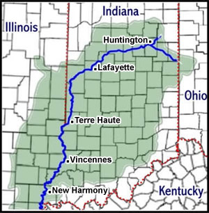
This web site documents the access
sites on the Wabash River from Huntington, Indiana
to the confluence with the Ohio River. It includes pictures
and descriptions of the access sites and their amenities.
We personally visited the access sites. The first half
of the river (from Huntington to Tecumseh) was done by
boat. We then drove to the access sites on the second
half of the river (from Terre Haute to the confluence
with the Ohio).
ABOUT THE WABASH RIVER
The Wabash has always been Indiana's most famous river.
Occupying the heartland of the state, the river drains
two-thirds of the 92 counties (over 33,000 square miles)
as it flows over 475 miles to its confluence with the
Ohio below Mount Vernon. The river rises in Ohio near
Fort Recovery and flows for only thirty miles before it
becomes entirely an Indiana River. In addition to being
Indiana's official state river, the Wabash is also the
longest free-flowing river east of the Mississippi.
It is a river of many faces and moods. At times it occupies
a huge valley which was carved by a glacial runoff but
it also flows through a partially filled valley formed
before the glacial advances. In its upper stretches the
Wabash moves across the fertile, flat land in a narrow,
shallow trench.
A trip down any other river in the state will not give
as complete a view of Indiana as the Wabash. You will
not experience a pristine natural environment (except
in isolated sections) but you will see Indiana today and
a glimpse of the past. The river is usually muddy and
slow moving as it drains much of Indiana's fertile farmland.
This factor alone should not deter you from trying the
Wabash. The upper end of the Wabash is very shallow with
numerous log jams clogging the river and making navigation
of the river tiring in all but high water (and then it
may be dangerous).
|